
A natural disaster hazard refers to a naturally occurring event that has a negative effect on the people and the environment and these can be divided into various types i.e the geographical and metrological hazards for example earthquakes, coastal erosion, volcanic eruption, cyclonic storms, drought, land slides etc as well as biological hazards like floods, wildfire etc.
Risk mapping tools refer to tools used by life savers/insurers to identify, control, and manage risk so as to come up with measures that provide solutions. Risk mapping is usually applied to aid in the identification, prioritization and quantification of risk.
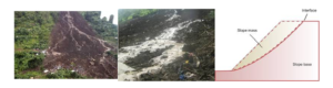
Illustration
We have experienced personnel who will offer you with specialized services and information about natural disaster mapping and GIS based on risk assessment in line with climate change and disaster risk reduction. We also use other tools and technologies to provide solutions for disaster prevention, mitigation, and preparedness.
The team’s expertise lies in using scientific methods to identify hazards, assess vulnerabilities, and model the overall impact of natural and man-made disasters. The solutions include Hazard identification, Exposure database development, Vulnerability assessment and Economic loss assessment.